September 12, 2018, 8 AM. It appears that Hurricane Florence will make a more Southern North Carolina or Northern South Carolina landfall on September 15, 2018. It is possible that it will be a Category 2 since it will slow down and be over cooler water. The cone of uncertainty is now between Myrtle Beach, SC and Cape Lookout National Seashore, NC.
The Euro Model has the storm tracking more south. This is good news for the Hampton Roads area if this track remains true. Virginia could receive 3 to 6 inches of rain. If the storm tracks more to the north, the rain amounts could be more. Once the hurricane makes landfall, if there are no steering wind currents, the storm could drift and produce massive rainfall, potentially up to 30 to 40 inches of rain.
The current position of Florence as of 8 AM EST was 29.4° N and 70.7° W or about 530 miles SE of Cape Fear, NC moving at 17 MPH. The wind speed is 130 MPH moving West-Northwest.
According to the National Hurricane Center (NHC), “A motion toward the northwest is forecast to begin by this afternoon and continue through Thursday. Florence is expected to slow down considerably by late Thursday into Friday, and move slowly through early Saturday. On the forecast track, the center of Florence will move over the southwestern Atlantic Ocean between Bermuda and the Bahamas today, and approach the coast of North Carolina or South Carolina in the hurricane warning area on Thursday and Friday.”
The National Hurricane Center advises, “Hurricane-force winds extend outward up to 70 miles from the center and tropical-storm-force winds extend outward up to 175 miles.”
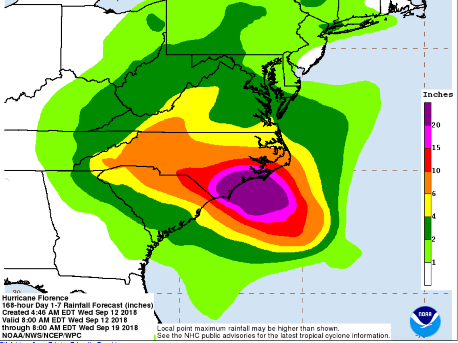
As for rainfall, The NHC wrote, “Florence is expected to produce heavy and excessive rainfall in the following areas…Coastal North Carolina…20 to 30 inches, isolated 40 inches South Carolina, western and northern North Carolina…5 to 10 inches, isolated 20 inches. Elsewhere in the Appalachians and Mid- Atlantic states…3 to 6 inches, isolated 12 inches. This rainfall would produce catastrophic flash flooding and significant river flooding.”
This hurricane is expected to be a significant rain event. As the storm nears the coast, the actual location of landfall can be better determined.
Please continue to pray that the storm will weaken and dissipate.
Reference: The National Hurricane Center https://www.nhc.noaa.gov/text/refresh/MIATCPAT1+shtml/121156.shtml
Copyright © September 12, 2018. The Lantern & Shield Times, a Division of Marketplace Evangelism Ministries Inc. All Rights Reserved.
